Industry Literature - January 14, 2019
To most people, GNSS satellites are something vague that fly around in the upper atmosphere. From there, the technical details tend to get a bit hairy. As long as they function correctly, who cares which ones we use for tasks like positioning and timing, right?
GPS vs. GNSS: Understanding PNT Satellite Systems
Not so fast. Not all systems are the same, and when it comes to business use, it's vital to understand the nuances. Here's a quick rundown that should cut through the noise to help you get a clear signal.
Positioning, Navigation and Timing Systems
A GNSS, or Global Navigation Satellite System, is a generic name for a group of artificial satellites that send position and timing data from their high orbits. The GPS, or Global Positioning System, is just one of the many different sets of satellites that can provide such data.
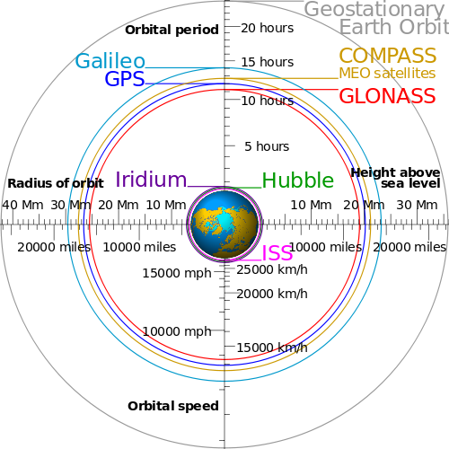
Most satellite navigation systems operate on similar principles. The satellites are arranged in controlled and carefully monitored orbits, which except for regional enhancements are chosen to ensure even coverage globally.
Since the individual satellites maintain their relative positions, they form stable artificial constellations. Each satellite is transmits its time and position, so that a receiver on the ground can use this signals to, in essence, triangulate in time and space to get its position and the time.
These satellite constellations vary in terms of their orbital heights and the speeds at which they whiz around their orbits. Other technical distinctions include the fact that they employ mostly unique radio frequency bands for their data transmissions.
No satellite navigation system is perfect. For instance, it takes time to prepare and launch reliable devices, and keeping them running is no minor feat. A ground-based receiver needs signals from multiple transmitters to get an accurate timing or positional fix, and the most populated systems only include a few dozen satellites. In other words, loss of a single signal may have a more significant impact in a constellation with fewer members to spare in the first place.
The U.S. spent years dominating the scene with the Global Positioning System. Even with the later addition of Russia's GLONASS, the options remained limited.
More recently, however, the playing field has become host to the European Union's global Galileo and China's regional BeiDou, once known as COMPASS. These systems are scheduled to be fully operational by 2020.
As nations compete to create functional, accurate, and secure satellite positioning and timing networks, it is only natural to differentiate between the diverse groups of artificial constellations.
Here are the Major Players
GNSS SYSTEMS
GPS
The Global Positioning System is owned and operated by the United States. The official US Department of Defense name for GPS is NAVSTAR.
BeiDou
BeiDou (or BDS) (formally known as COMPASS) is a regional GNSS owned and operated by the People's Republic of China. As of 2020, BeiDou consists of 35 satellites, offering global coverage.
Galileo
Galileo is the European Union’s global GNSS. The EU plans to complete the system in 2021.
GLONASS
GLONASS (Global Navigation Satellite System) is owned and operated by the Russian Federation. The fully operational global system consists of 24+ satellites.
REGIONAL ENHANCEMENTS
WWAS, EGNOS
WAAS, for North America; and EGNOS, for Europe, provide geostationary satellites as enhancements to GPS. While the satellites can be used for positioning, they also serve an important function of providing improved and more current information about troposphere, ionosphere, GPS satellite positions, and GPS satellite clock time offsets, including integrity information about malfunctioning satellites. EGNOS, a European system, will provide a similar service for Galileo in the near future.
QZSS
QZSS, or Quasi-Zenith Satellite System, is a regional system operated by QZS System Service Inc. (QSS) and owned by the Government of Japan. QZSS works with GPS to improve coverage in East Asia. The constellation is operational with 4 satellites. By 2023, Japan plans to have 7 satellites for autonomous capability. QZSS satellites are geosynchronous in that they orbit the Earth exactly once a day, so that they always appear to be at roughly the same longitude in the sky. However, they are in highly inclined orbits so that their latitude varies considerably over their orbit. They reach their highest distance from the Earth when over Japan. When over Japan, their signals beam straight down and this gives greater coverage in “urban canyons”, where buildings block signals from low-elevations. At the higher altitude they also travel slower, so that they spend much more time over their home country. Then they complete their orbit by traveling south and zooming over Australia before returning north.
Beidou
Beidou has geostationary satellites associated with its constellation. Their orbits are more conventional. They are not inclined, and so the satellites always appear to be at the same position over the equator.
Which GNSS System Should You Use?
What does all this mean for companies that depend on GPS or GNSS for tasks like high-fidelity network timekeeping? In the end, users may be better off not playing favorites. Multi-GNSS can solve problems like outages by using a variety of different systems. For instance, if part of the GPS satellite constellation fails, the receiver might fall back on GLONASS, BeiDou, or Galileo. This capability means that users don't have to stick to a particular option to enjoy reliable timing and positioning feedback.
In the end, your choice of satellite constellations should reflect your use case. For instance, if you were deploying a network in a particular country, you'd probably go with whichever positioning system provided the most accurate information. National security embargoes and other political issues can also impact the viability of specific alternatives. GNSS threats like jamming and spoofing can also impact performance.
Masterclock offers both GPS and multi-GNSS receiver options with our configurable master clocks. If you’d like to learn more about GNSS-synced timing, contact us today.
Return to Knowledge Center to learn more.
Presentation by John Clark, CEO & Dr. Demetrios Matsakis, Chief ScientistTime Behind and Beyond the Clock